Red-winged Blackbirds at Wolf Road Prairie

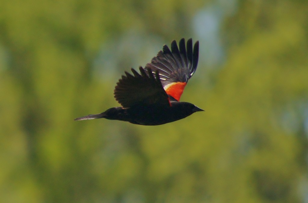
The male red-wing black bird is easy to identify because he wears his bright ID patch atop his wing shoulders. His red-orange patches with a yellow border at the bottom distinguish him from other members of the blackbird family. These patches, or epaulets, as they are called, play an important role in the male’s ability to maintain territory and attract a mate. Males with larger brighter epaulets can better intimidate males vying for the same territory and are more likely to be successful in attracting multiple mates. Interestingly, the older a male gets to be, the more brilliant his patches and the more lustrous the shine of his black feathers.


When the male fully displays his bright patch while fanning his tail feathers, he is either defending his territory or doing his best to attract a female. The males will also display during flight deliberately slowing down their wing strokes to ensure that their epaulets are not missed by other males or available females.


In one experiment, the epaulets of some male red-wings were blackened out. These unlucky males were no longer able to maintain their territories. In the world of the red-winged blackbird, brilliant epaulets equal status. ( Sophie Brown of the Cornell Lab of Ornithology )


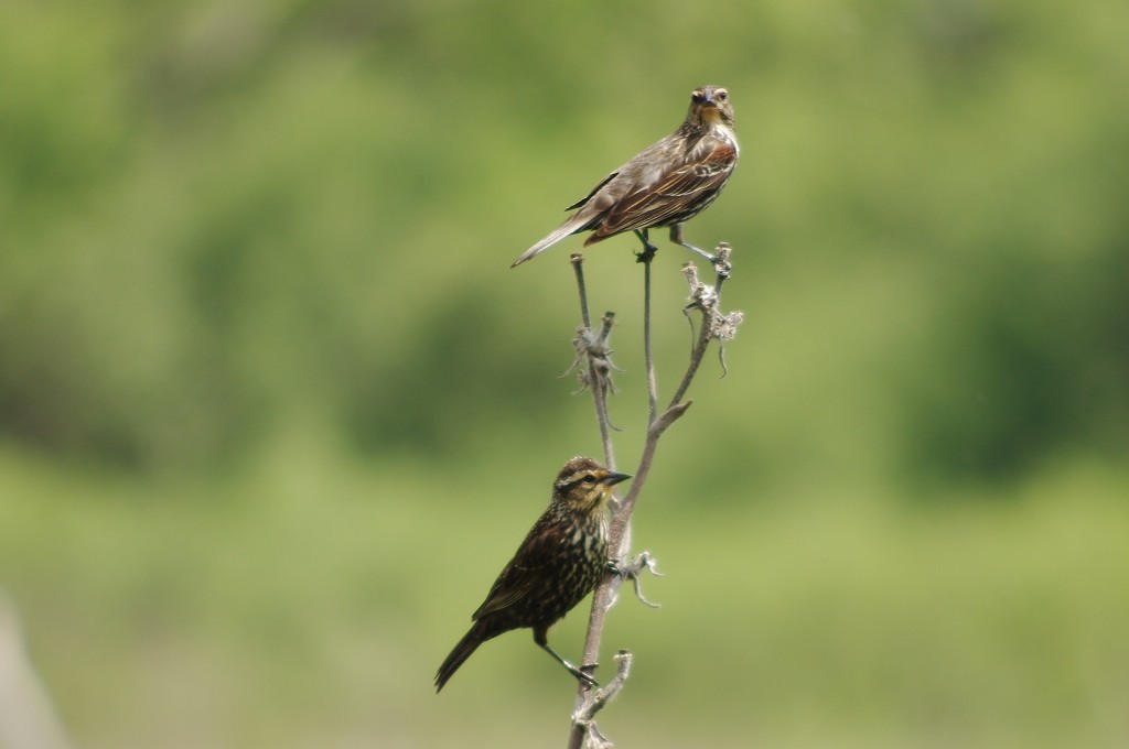
The beauty of the female is in her many subtle colors including gray, brown, and salmon-pink. She has a noticeable white stripe over her eyes easily seen in Fidencio’s photo.


Written by R. McCabe

Photos by Fidencio Marbella

Biodiversity & Wolf Road Prairie

Much of the time and effort to keep Wolf Road Prairie healthy by Save the Prairie Society members, the FPDCC, the IDNR, and volunteers is devoted to promoting and preserving biodiversity. Biodiversity is one of the key indicators of productivity, health, and stability of an ecosystem. But what is biodiversity, why is it important, what threatens it, and how is STPS helping to to enrich Wolf Road Prairie’s own biodiversity?


Biodiversity Explained

Broadly speaking, biodiversity refers to the variety of organisms within an ecosystem. However, scientists quantify biodiversity on three different levels; genetic diversity, species diversity, and ecosystem diversity.

  • Genetic diversity counts the total sum of genetic information of individual organisms within a single species. Having sufficient genetic diversity within a species is important for preventing detrimental inherited traits and fighting disease.
  • Species diversity refers to the number of different species in either a single ecosystem or on Earth as a whole. Scientists utilize taxonomy to see historical species diversity and can discover why some evolutionary branches of organisms are more species-rich than others through time.
  • Ecosystem diversity describes the study of different biological communities and their abiotic habitat within a given region. This level of biodiversity is the most difficult to quantify. As explained on our blog, ecosystems are dynamic and exist on a spectrum where clear boundary lines are blurred. Therefore, in studying ecosystem diversity, scientists measure changes within biological communities along with any shifts in their physical environment.


Why is Biodiversity Important?

Having rich, biodiverse ecosystems directly benefits humans. High biodiversity ecosystems have high productivity (how much biomass is produced within an ecosystem), high quality soil, aid in local weather patterns, cycle nutrients more effectively, retain and recharge surface and ground water, prevent flooding, and improve air quality by releasing oxygen. Having a diverse biological community allows for wildlife to more efficiently utilize that ecosystem’s resources, facilitate population health in other species, and help stabilize and recover from ecological disturbances. Humans also gain economically from healthy ecosystems, as biodiverse regions provide services and resources such as fishing, agriculture, forestry, and even tourism.

Biodiversity can also better stave off accelerated mass extinction and in turn improve our current quality of life and abundance of natural resources and services. While extinction of species has occurred in the past and will continue in the future, scientists today are largely concerned with the rate organisms are dying off. Some estimates of current extinction rates are 100 to 1000 times what is found in the fossil record. Humans will ultimately be effected by such an accelerated mass extinction as air quality declines, weather becomes more erratic, and natural services and resources become more and more sparse.


Threats to Biodiversity

Combating threats to biodiversity is a multi-front war and oftentimes these threat vectors work in conjunction with one another. Habitat loss and fragmentation, overhunting, pollution, over-farming/over-harvesting, native species competition, and even natural, non-anthropogenic causes (such as earthquakes, fires, droughts, etc) are significant threats to biodiversity and may occur simultaneously. STPS routinely battles another enemy to the biodiversity of Wolf Road Prairie—non-native invasive plant life.

Buckthorn, teasil, reed canary grass, and bull and Canada thistle are all alien plants to Illinois which compete for resources and displace native plant life. By out-competing native plants, invasives reduce biodiversity on multiple levels. For instance, bull thistle outcompetes and disestablishes native plant life on the prairie if left unchecked. Native thistle is a food source for a variety of native wildlife, such as goldfinches and deer, but because of of bull thistle’s spines and seed size, most cannot utilize them with the ease in which they access native thistle.


How STPS Promotes Biodiversity at Wolf Road Prairie

STPS and volunteers work tirelessly to rid the prairie of alien plant life. Equipped with bug repellent, hand shears, and loppers, workers trek the prairie and eliminate threats. During the summer months, STPS worked on clipping spiny bull and Canada thistle. Elimination of bull thistle began in June when it’s flowers began to bloom but before the flower opens and seeds can ride the wind and spread to other areas of the prairie. Bull thistle is also most vulnerable at this stage as most of it’s energy is directed towards producing its flower rather to its root system. Flower heads are individually collected to prevent the seeds from spreading before cutting the plant at the base. This fall, our attention turned to buckthorn. We even had help from the local Nazareth High School students to cut down the woody exotic. Restoration efforts, including mechanized work, herbiciding and prescription burns, are also being conducted during the winter months to cull harmful exotics and promote prairie health.


What You Can Do to Help

STPS is an all volunteer organization and promoting biodiversity in Wolf Road Prairie’s incredibly threatened ecosystem is no small task. If you would like to contribute to the ongoing efforts to save Wolf Road Prairie, there are a variety of ways to help. Contact us by phone or online if you would like to volunteer your time to STPS. You can also contribute by donating. Checks can be made out to ‘Save the Prairie Society’ and be sent to:

Save the Prairie Society
11225 Constitution Drive
Westchester, IL 60154

You can also donate online securely via PayPal.

Lastly, you can help us by spreading the word about STPS. Please share our homepage, facebook, and twitter to those you know who are also concerned about the natural world. Thank you for helping promote local biodiversity!

–F. Martino

SOURCES

Freeman, Scott. Biological Science. San Francisco: Pearson/Benjamin Cummings, 2008. Print

Wolf Road Prairie Beach?

We are currently in the Quarternary geological period, which began about 2 .6 million years ago. This period is characterized by repeated cold glacial episodes (ice ages) alternating with warm interglacial episodes, each lasting tens of thousands of years.

Northeastern Illinois was covered at least six times by continental ice sheets that came down from Canada, cutting and deepening the basins of the Great Lakes along the way. The last sheet was the Wisconsin Glacier that retreated from Illinois into Lake Chicago (the precursor of today’s Lake Michigan) about 12,500 years ago, leaving behind 10 or more feet of sediment known as glacier drift, including a few large rocks called “glacier erratics” that can be found scattered over Wolf Road Prairie.


Glacial erratic at Wolf Road Prairie


At its maximum, the glacier was over 3000 feet thick in Chicago and extended as far south as Peoria and Shelbyville, smoothing and flattening the bedrock topography of Illinois. The front or leading edge of the glacier advanced and retreated many times, leaving behind a series of long elevated ridges or hills known as moraines. Wolf Road Prairie is currently located on part of the large Valparaiso Moraine that extended around the bottom of Lake Michigan from Wisconsin through Illinois and into Indiana. The shoreline of Lake Chicago was as far as LaGrange Road, making Wolf Road Prairie almost “beach front property.” Obviously the lake was much higher then, and as recently as 3,000 to 4,000 years ago water from Lake Chicago flowed out south and west via the “Chicago Outlet” through low parts of the Valparaiso Moraine, forming the Des Plaines and Sag River valleys and connecting Lake Chicago with the Mississippi River system.

Much of the current Palos Forest Preserve, including the Little Red School House nature center, was located on Mount Forest Island between the Des Plaines and Sag rivers. Today thanks to the construction of the Chicago Sanitary and Ship Canal over 100 years ago in 1900, Lake Michigan again flows into the Des Plaines River, but that may not last due to fears that the Asian Carp may use this restored ancient water route to enter the Great Lakes.

Next time you’re at the Prairie keep an eye out for those glacial erratics and try to imagine a sheet of ice as high as two Willis Towers above you!

–E.J. Neafsey

Source: “Geology of Illinois,” edited by Dennis R . Kolata and Cheryl K. Nimz, University of Illinois at Urbana-Champaign, 2010.

Wolf Road Prairie: A Primer

While Wolf Road Prairie occupies only 80 acres today, tallgrass prairies spanned across the entire Midwest as early as 170 years ago. According to the US Geologic Survey, less than 1% of tallgrass prairies remain in Illinois.  That means if you live in the Chicagoland area you have one of the most endangered ecosystems in the world practically in your backyard.


But what defines this incredibly rare ecosystem? When most think of what characterizes tallgrass prairies they think of just that—an area covered primarily in tall grasses. This is for the most part correct, however nature is never so simple. While scientists have widely categorized prairies based on their vegetation, soil, landscape, climate, etc, the tallgrass prairie ecosystems are difficult to pigeonhole. As Ladd and Oberle state in their book Tallgrass Prairie Wildflowers:


There is no single model of a tallgrass prairie but rather an endlessly variable, dynamic tapestry of plants and animals that for thousands of years have been responding to and in turn influencing their landscape and each other.


Wolf Road Prairie is no exception; even within its 80 acres the prairie can be divided into 3 different broadly defined prairie types.


Savanna

You may typically think of a savanna as an ecosystem that occurs on another continent, such as the Serengeti, but savannas are any tallgrass prairies that include trees. But unlike a forest where little to no sunlight can penetrate the canopy, these trees are interspersed. Trees, such as Wolf Road Prairie’s 250 year old Bur Oaks are often found on tallgrass prairie savannas. You can find the savanna on the southern end of Wolf Road Prairie.


Mesic Prairie

North of the savanna is the mesic prairie. Mesic prairies, like wetlands, retain moisture but are able to drain excess water. This produces rich soil and allows mesic prairies to support some of the most abundant and exquisite flora of any prairie ecosystem. The sidewalks laid down before the Great Depression provide walking paths through this highly threatened ecosystem.


Wetland Prairie

The northern 40 acres of Wolf Road Prairie host the wetland portion of the prairie. Wetlands are defined by being heavily hydrated by means of groundwater seepage, bodies of water such as rivers, or other natural means to keep the soil completely saturated throughout springs and summers. Normally, it is not even possible to trek through the Wolf Road’s wetland until the dry season (unless you have the proper gear!) when a narrow pathway opens. But because of this year’s harsh and severe drought, most of the wetland has been relatively dry. We are hoping the winter and spring weather will help the wetland recover.


Next time you visit Wolf Road Prairie, remember how complex, subtle, and nuanced nature is as you walk through one of the rarest ecosystems in the world.


– F. Martino

Last edited 12/9/2012

SOURCES

Ladd, Doug , and Frank Oberle. Tallgrass Prairie Wildflowers. 2nd ed. Guilford, CN: Morris Book Publishing, LLC, 2005. Print.

Potawatomi Peoples lived at Wolf Road Prairie and Hickory Lane

Wolf Road Prairie and Hickory Lane were located within the historic geographic boundaries of the Pottawatomi village of Saugannaka. A signal station, chipping stations, camps, mounds and trails were characteristic of this settlement along Salt Creek in Cook and DuPage Counties until the Blackhawk War of 1832. Following the war, the territory of Illinois opened to European settlement and native people were moved westward across the Mississippi River.

An arched trail tree still remains on Hickory Lane, a reminder of use of this area by native peoples.

Today, the history of our region’s Native American people is nearly forgotten as subdivisions, corporate complexes and shopping centers cover the lands of old native villages, outstations and sacred burial sites.

The Wolf Road Prairie area offers a location where the lives and cultures of Native Americans of the region can be remembered. The site can help preserve this Native American heritage from extinction in a historically accurate landscape setting.

Below is a map of the boundaries of Sagannaka. Wolf Road Prairie and Hickory Lane are located in the right hand square which extends into Cook County north of 31st Street.

Village boundaries from a map by Albert F. Scharf, 1900.

Geologic and Hydrologic Report

A Geologic Information System and Hydrologic Survey of Wolf Road Prairie Nature Preserve Westchester, IL.
(Excerpts)

Prepared by: Ana Cichowski, Lacy Smith, and James Clark
Wheaton College, Wheaton, IL

June 2, 2004

Purpose of Project: The main objective of this project was to understand the hydrology of Wolf Road Prairie by gathering, organizing, and analyzing data into a Geographic Information System database. With this information a groundwater model for the site is being developed. The results of this analysis will aid in the preservation and management of the prairie.

GIS Mapping: Using Global Positioning System (GPS) technology a map of the current actual outline of the prairie and prairie features was drawn. The data was collected by slowly walking the GPS unit along the sidewalks, paths, monitoring wells, and trenches of the prairie while the unit took readings from satellites. The readings were corrected for errors by using the information from a local fixed GPS base station.

GIS Analysis: The GIS map database is helpful in recording, compiling and maintaining prairie data. It is also useful in providing a database of visual images, namely aerial photos.

The completed GIS database reveals interesting changes over time. The DOQ and 1938 aerial photograph show the sharp contrast between current and historical prairie development. The historical photo emphasizes the abundant farmland surrounding the prairie, with only Wolf Road and 31st street as obvious features. Photographed about 60 years later, the DOQ emphasizes the urbanization that now approaches the prairie borders. A significant increase in pavement and a noticeable rise of urbanization often trigger changes within places like Wolf Road Prairie because of the diversion of groundwater flow and the increase of surface runoff.

Hydrological Analysis: The ultimate goal of this survey is an analysis of the groundwater flow.

The intention is that these results can aid in understanding the migrating wetlands and changing prairie. A varying water table means the difference between a prairie, where plants must absorb air through their roots, and a wetland, where plants thrive in the saturated ground.

Seismic Refraction Survey: Seismic refraction is a geophysical method frequently used to determine depth to the water table, to geologic layers, and to bedrock.

Seismic refraction is a geophysical technique that uses the movement of seismic or sound waves to delineate geologic layers based on changes in seismic velocity of different strata. Analysis of this data provides an understanding of the subsurface nature of the prairie in relation to groundwater movement and drainage.

Seismic Refraction Results: The seismic results confirm that a distinction between soil types occurs at about 7 to 8 feet below the surface.

The velocity of the upper layer is consistent with a sandy/silty unconsolidated soil. The lower level velocity indicates a consolidated gravel/till horizon. Therefore, because of the impermeable nature of the lower horizon, the majority of the ground water affecting the prairie will be confined to the upper 7 to 8 feet.

Conclusions and Recommendations

This survey consisted of two parts: compiling and analyzing existing spatial data using ArcViewGIS and studying the hydrology of Wolf Road Prairie. The projects were interrelated in that GIS is helpful in understanding the layout of the prairie and the relationship it has with the hydrology. Both projects were largely successful, although more data would improve all of the results.

The GIS map database consists of: USGS topographic map, color air photograph, historical air photograph, digital elevation map (DEM), Global Positioning System (GPS) survey, ground penetrating radar (GPR) survey, and digital orthophotoquad (DOQ). If more data are collected, such as vegetation maps, bird/animal migration, wetland delineations, etc., they can be included in the GIS if accurate locations are available. The entire GIS can be imported into ArcExplorer, a free GIS reader. This freeware offers viewing, printing, and some analysis of the data.

The GPS information provided maps of the exact current outline of the prairie and prairie features. It would be of further benefit to the prairie to purchase a GPS unit for marking delineation of burn areas, wetland, prairie, and savanna areas, and vegetation distribution.

The hydrologic data and model simulations suggest that urbanization has had a large impact on the groundwater flow and seasonal groundwater levels. Thus the migration and shrinking of the wetlands may be directly related to the increased pavement and diversion of water from the prairie area, especially within the last 60 years.

Prairie House Nature Center

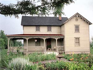
The circa 1850’s Franzosenbusch Prairie House represents more than 150 years of local history, and is considered the oldest structure in Westchester. Situated at the north end of the original 12,000 to 15,000 year old Wolf Road Prairie, the house serves as the gateway to the preserve. The Prairie House is being restored as a nature center and museum.
houseafterPC

The Prairie House represents three distinct historic periods of construction dating from c.1852 through c.1870. The new addition, funded by an Illinois First grant, was constructed in 2000 at the rear of the building to provide an activity room, public washrooms and handicap access.

The original two rooms within the Prairie House date back to early settlement of the area known as Franzosenbusch when German immigrants arrived here from Hanover, Germany. In c.1853 the building served as the first Lutheran schoolroom and teachers’ quarters in Proviso Township. At this point in the history of the building, the structure was a stand alone schoolhouse containing two small rooms with its own four walls, peaked roof, student doors, narrow windows and living space for teachers and their families. Heat was provided by a small cast iron stove which was also used for cooking. There was no running water, electricity or indoor plumbing. Records indicate that one married teacher, his wife and seven children lived in these spartan and cramped quarters. The children slept in the loft of the schoohouse on beds of straw. The schoolhouse was also used briefly for church services and community gatherings.

As the Franzosenbusch community grew and prospered, the original schoolhouse became too small. In about c.1858, a new school building was constructed, and the old schoolhouse was converted to a farmhouse. The western addition of the house was attached at this time. Around c.1870 the building was enlarged again. This time the south facing section of the house was expanded by about ten feet, and the second floor was added.

The original schoolhouse within the structure contains elements of medieval German “fachwerk” half-timbered frame construction, a rarity in Illinois. Additions to the house were constructed in the modified balloon frame style of architecture. This construction style became famous in rebuilding Chicago after the Great Fire of October 9, 1871. Today the Prairie House provides:

  • A time capsule of 19th Century lifestyles and cultures only a moment away from the sights and sounds of the 21st Century.
  • An educational facility for students, teachers and the general public including prairie tours, natural history, Native American history, early settlement history, botany, biology, ecology and native ecosystem restoration programs.
  • An authentic replication of the first Lutheran schoolroom/teacherage in Proviso Township with information about the early days of this German farming community and the founding of the village of Westchester. For more information on the history and genealogy of the area see http://www.franzosenbuschheritageproject.org),an independent web site of Franzosenbusch Heritage Project, an affiliate of Save the Prairie Society.
  • A gathering place for lectures, programs, classes and events with a meeting room available for use by conservation, scientific, historic, cultural, youth and civic organizations.
  • The Prairie House Gardens present a colorful blend of formal designs and hardy perennials against the backdrop of the original prairie grasses and wildflowers.
  • A place to celebrate special occasions and join in ceremonies, performances, art exhibits and historical re-enactments.
The Prairie House represents three distinct historic periods of construction dating from c.1852 through c.1870. The new addition, funded by an Illinois First grant, was constructed in 2000 at the rear of the building to provide an activity room, public washrooms and handicap access.
The original two rooms within the Prairie House date back to early settlement of the area known as Franzosenbusch when German immigrants arrived here from Hanover, Germany. In c.1853 the building served as the first Lutheran schoolroom and teachers’ quarters in Proviso Township. At this point in the history of the building, the structure was a stand alone schoolhouse containing two small rooms with its own four walls, peaked roof, student doors, narrow windows and living space for teachers and their families. Heat was provided by a small cast iron stove which was also used for cooking. There was no running water, electricity or indoor plumbing. Records indicate that one married teacher, his wife and seven children lived in these spartan and cramped quarters. The children slept in the loft of the schoohouse on beds of straw. The schoolhouse was also used briefly for church services and community gatherings.
As the Franzosenbusch community grew and prospered, the original schoolhouse became too small. In about c.1858, a new school building was constructed, and the old schoolhouse was converted to a farmhouse. The western addition of the house was attached at this time. Around c.1870 the building was enlarged again. This time the south facing section of the house was expanded by about ten feet, and the second floor was added.
The original schoolhouse within the structure contains elements of medieval German “fachwerk” half-timbered frame construction, a rarity in Illinois. Additions to the house were constructed in the modified balloon frame style of architecture. This construction style became famous in rebuilding Chicago after the Great Fire of October 9, 1871. Today the Prairie House provides:
A time capsule of 19th Century lifestyles and cultures only a moment away from the sights and sounds of the 21st Century.
An educational facility for students, teachers and the general public including prairie tours, natural history, Native American history, early settlement history, botany, biology, ecology and native ecosystem restoration programs.
An authentic replication of the first Lutheran schoolroom/teacherage in Proviso Township with information about the early days of this German farming community and the founding of the village of Westchester. For more information on the history and genealogy of the area see http://www.franzosenbuschheritageproject.org),an independent web site of Franzosenbusch Heritage Project, an affiliate of Save the Prairie Society.
A gathering place for lectures, programs, classes and events with a meeting room available for use by conservation, scientific, historic, cultural, youth and civic organizations.
The Prairie House Gardens present a colorful blend of formal designs and hardy perennials against the backdrop of the original prairie grasses and wildflowers.
A place to celebrate special occasions and join in ceremonies, performances, art exhibits and historical re-enactments.

Bird List

Download the  Bird-List-for-Wolf-Road-Prairie as a Word Document.

Images of some of the listed species known to Wolf Road Prairie appear in the Wolf Road Prairie Virtual Tour.

If you have difficulty opening this link, right click on “Bird List for Wolf Road Prairie” and click on Save Target As…, and save the list in your My Documents section of Microsoft Word.